
Gribo
-
Posts
225 -
Joined
-
Last visited
-
Days Won
7
Content Type
Profiles
Forums
Downloads
Gallery
Posts posted by Gribo
-
-
Should I create a new entry into the un-certified repository? It will make it easier to update the file.
-
Hello,
Following my previous attempt with Google maps, Here is a websocket based link between LV and Google maps.
Websocket class by S.Marlow http://evexiallc.com/index.php
JSON API by drjdpowell
Javascripts and demo application are based on the Webpanel demo application.
Instructions:
1. Obtain a Google maps API key.
2. Edit the WP_Googlemaps.html and add the key to the relevant script tag.
3. Start the demo vi (google maps demo.vi)
4. Open the WP_Googlemaps.html with a modern browser.
I have tested it with Chrome and Safari on iPhone 4.
You might have to point to the correct path of some VIs, they are included in the vi directory.
-
Title says it all..
I can edit my own posts in other forums.
-
You need to get your own Google maps API key, it is free. You are not supposed to share it with others.
Also, this http://lavag.org/topic/17870-lv-google-maps-via-web-sockets/
The API key string is located in the HTML document.
-
The diagram clean up button. No one else will have a 'Make code look nice' button. I wish I had it in other parts of my life...

-
The 0.7 update was posted. This tool is useful for a proof of concept only, to show geo spatial information generated from LV. The Javascript side of the project needs some more work (Paths, better JSON support).
-
This is a dead end code. Websockets are the future. I will post the last update next week.
-
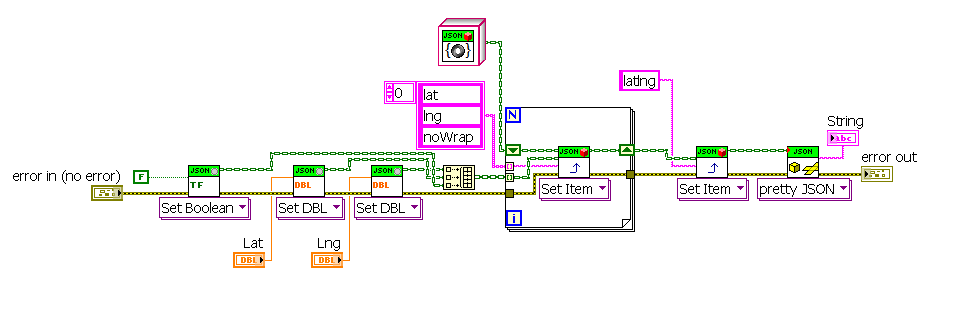
I am stuck. Trying to get the next function (Polylines) to work is quite complex. I need to pass an array of coordinates (Latitude, Longitude) to the browser, but cannot get it to understand JSON objects. Does anyone have an advise regarding this? Taking it one step at a time, I am trying to pass a single coordinate cluster. Below is the Javascript code:
function addmarkerJSON (Pmap, latlng, Title){//var Platlng = eval ('('+latlng+')');var Platlng = JSON.parse (latlng,function (key, value) { var type; if (value && typeof value === 'object') { type = value.type; if (typeof type === 'string' && typeof window[type] === 'function') { return new (window[type])(value); } } return value;});var options = {position: new google.maps.LatLng(Platlng.lat,Platlng.lng),map: Pmap,title: Title};alert(Platlng.lat);PMarker = new google.maps.Marker (options);return latlng.lat;}
-
The icons. 32x32 pixels on the block diagram?
-
Added an API test file. It draws a circle, animates it and creates a marker.
-
Name: Labview <-> Google maps VI
Submitter: Gribo
Submitted: 12 Nov 2013
Category: *Uncertified*
LabVIEW Version: 2011
License Type: BSD (Most common)
Connects to google maps javascript V3 api using the web browser .NET object (it exposes the HTML DOM model, where as the ActiveX control does not). This is an improvement over the examples from NI, as it allows dynamic adjustments to all of the map objects. Currently, only circle and marker are implemented.
-
 1
1
-
[CR] LabView <-> google maps websocket interface
in Code Repository (Uncertified)
Posted
Name: LabView <-> google maps websocket interface
Submitter: Gribo
Submitted: 29 Dec 2013
Category: *Uncertified*
LabVIEW Version: 2012
License Type: GNU Public
A simple bi-directional interface between Labview and Google maps, using Websocket.
See readme.txt for instructions.
Click here to download this file