wewtalaga
-
Posts
15 -
Joined
-
Last visited
wewtalaga's Achievements
")
Newbie (1/14)
0
Reputation
-
Good day! I'm planning to make a 3-floor miniature elevator (this is the prototype) and it will be controlled through LabVIEW. The LabVIEW interface will control what floor will it go up and down. But I have (super) major problems. First, which one is better to use for the interaction of prototype and labview, DAQ or Arduino? Next is that I don't have that much idea how to start the VI. I've seen some elevator VIs but I think I must read or research more. Also, is there a transfer function involved in the VI? All help will be greatly appreciated. Thank you.
-
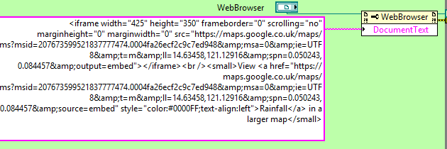
What I'm saying is I would like to replace the KML file I provided. In what part in the path below will I change?

-
What if I'm planning to change the KML file shown. In what part of the path will I edit it?
-
Oh thank you. Actually, that is what I'm looking for, an easy way to show it. I also don't have plans on changing it from my VI. I just want to show the KML file. Thank you. I'll post here if I have questions.
-
How can I put this KML files with google map on my VI? KML files.zip RAINFALL2 mod.vi
-
How can I put the browser to the LabVIEW? Is there some kind of URL?
-
I made a KML file. How can I put it in Google Map and put it in LabVIEW? Should I download the packages you mentioned?
-
Okay okay. I will check the link. Actually, I searched about KML and I found some sites on how to make them. Thank you! I will post here the results soon.
-
I could not open the VI properly. It has some errors where subVIs are missing.
-
Thank you very much. I will try it and post the results here.
-
I tried but I got confused for a bit so I erased it. So I tried changing a color of an image by replacing a new color (example, looking for a color green and changing all green to white) but I'm still not sure if I'm on the right track. I looked at the link you said and I have a question. If I'm going to make a KML file to load it on Google Map, will the coloring part be done through the map's coordinates?
-
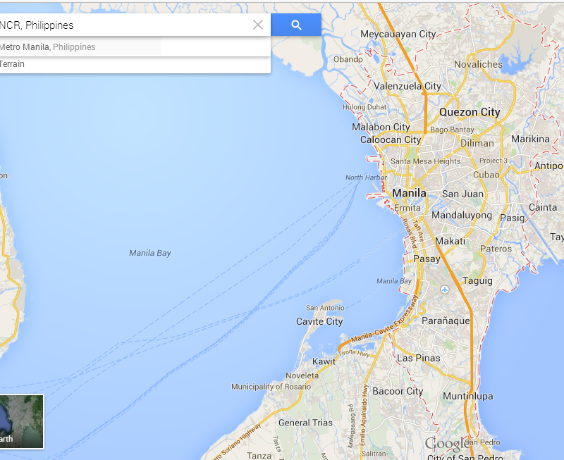
Good day! I want to ask how can I color some parts of the Google Map. I'm a bit of a beginner in LabVIEW (still learning the ropes) that's why I searched about putting a google map in LabVIEW and I found some. The question is, how can I add colors to them? In a specific place? Not exactly a pure color but just a shade to them? Here's what I'm planning to do. That's the Google Map of NCR (some place here in the Philippines) and I'm planning to add colors to some parts. How can I do it? Thank you very very much for the help.
-
Changing colors in a specific part of image
wewtalaga replied to wewtalaga's topic in Machine Vision and Imaging
Thank you very much for the help. By the way, what is the array for in the image data of the Draw Flattened Pixmap? -
Changing colors in a specific part of image
wewtalaga replied to wewtalaga's topic in Machine Vision and Imaging
For example, in the attached photo, I want to change the encircled part to color yellow. How can I do it? Or how would I change the blue parts of the image to green? Thank you.
-
Hello there! I wanna seek help in changing the colors in a specific part of an image. Example, in the lower part of image is blue, I want to change it to green, how would I do it? I guess that the way to change is through IMAQ but I am a bit of a beginner in IMAQ. Thank you.